Many air masses affect BC, Canada. (The station from the previous blog post was off of Addenbrooke Island, but for the sake of this blog post I will be looking at all of BC’s air masses and more specifically Victoria)
In the wintertime this area experiences the very cold and dry continental arctic air masses (which brings cold winters with a lot of precipitation) (cA)
In the summertime, this area experiences air masses coming from different areas around North America;
· mP-Maritime arctic air mass-(winds go south and bring cool wind, travels over large bodies of water-mild & moist)
· mP- Maritime polar air mass-(from the Pacific and Atlantic, bring a lot of rain fog and snow because it is cool and moist.)
· mT-Atlantic maritime tropical air mass-(from the Gulf of Mexico that moves up. This bring heat and humidity to eastern Canada)
· mT-Pacific maritime tropical- has a cooling effect.
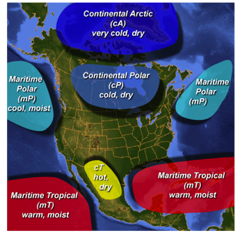
This image provides a visual to see what air masses affect BC Canada. http://apollo.lsc.vsc.edu/classes/met130/notes/chapter11/na_airmasses.html
Cold-front occlusion also occurs frequently in this area, and this is when a cold front (like the continental arctic air mass) front forces itself under the warm front (such as the maritime or pacific air masses).
This area does also experience many mid-latitude cyclones, within these baroclinic zones, where fronts and air masses collide in a low pressure area.
This area does also experience many mid-latitude cyclones, within these baroclinic zones, where fronts and air masses collide in a low pressure area.
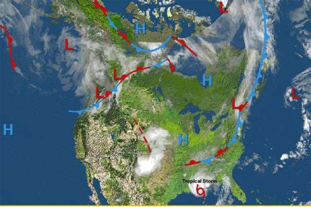
This image shows a typical mid-latitutde cyclone over the Canadian Region. Notice the high and low pressure patterns, as well as air mass movements. http://ec.gc.ca/meteoaloeil-skywatchers/default.asp?lang=En&n=149C159E-1
The next few days in BC Canada seem semi-mild temperatures and low precipitation. The weekend is looking at highs in the mid 50’s and lows in the upper 30’s. Saturday may be a little cloudy with some rain. The image below is a radar image of Today’s afternoon, and as seen below there are some areas of rain/snow and clouds.
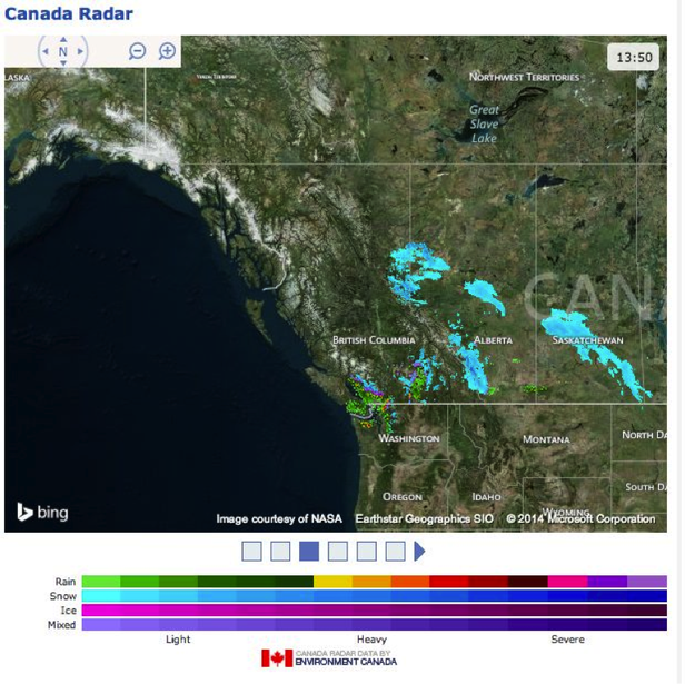
The fronts affecting the next few days in this area include the mP (Martitime Polar) moving in West, bringing some moisture and precipitation into the area. http://www.accuweather.com/en/ca/victoria/v8t/weekend-weather/47163
Most of Canada including BC has unique factors affecting the climate. The climate itself varies from marine to continental. To the West is the Pacific Ocean, which brings warm moist air and westerly winds to the country.
The rocky mountain region that is in Canada that runs North-South affects the jet streams greatly, slowing and changing the wind strengths and precipitations. This terrain causes intense changes in climate conditions over small areas of distance.
The North latitude of this area itself also brings effects to the climate, it is closer to the North Pole and the strength of the Polar jet stream is stronger here, forming the biggest front.
In general, the climate in BC is varied, but mostly can be generalized as wet cold winters, with milder summers. All of the geography and location of BC causes changes and intensifications of the climate and precipitations.
Sources:
http://www.canadiangeographic.ca/atlas/themes.aspx?id=weather&sub=weather_basics_begins&lang=En
http://www.britishcolumbia.com/information/details.asp?id=16
http://en.wikipedia.org/wiki/Geography_of_British_Columbia#Climate
http://www.worldatlas.com/webimage/countrys/namerica/province/bczland.htm
Along with class notes from Fred. Chambers’ Weather & Climate course
 RSS Feed