For Vancouver, BC the station is located off of the coast of Vancouver Island, near Victoria. This station is affected by many climate controls at both the Meso and Micro scale.
Meso Scale affects:
a. Mountains, those ranges including the Canadian Rockies, Coast Mountains, Cassiar Mountains and the Columbia Mountains, dominate the province of British Columbia. These mountains are one of the main climate controls in this region, dominating the weather and precipitation patterns in almost the whole province. These mountain ranges lift, and in turn, spread precipitation, blocking precipitation coming in from the West from the Pacific ocean, causing most of the precipitation to fall on the West side of these mountain ranges. These ranges slow and diminish the flow of cold arctic air that comes in from the North and the West during the winter seasons (Nov-Jan in the Northern Hemisphere). The variability of precipitation is also therefore affected, causing large ranges in precipitation all over the province.
b. This weather station is off of the coast of Vancouver island- right next to the Pacific Ocean. This coast of BC experiences a lot of precipitation during the winter due to the pressure patterns coming from the Pacific Ocean. This warm and high energy patterns bring in some precipitation in summer seasons, although mainly bringing in snow in Winter Months.
c. Air mass dominances as shared in the previous blog post, also have an affect on this area’s overall climate. These air masses include mainly continental arctic air in the winter and Maritime arctic air, Maritime polar air, Atlantic maritime tropical air mass and Pacific maritime tropical in the summer.
Micro scale climate controls also affect this station. These include:
a. Naturally occurring valleys and bodies of water such as lakes can affect the climate of certain areas. The higher a location is, such as on a mountain, the more precipitation there is. The weather is also warmer in the valleys in the winter seasons.
b. There are not many anthropogenic affects at this station’s location. The area is fairly untouched by humans, with no close proximity to cities or industrial areas, having therefore no climate affects from urban heat islands, unnatural vegetation changes, or direct pollution .
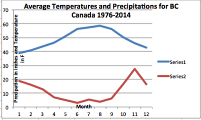
This graph created by me, uses data from the http://www.ncdc.noaa.gov, for the exact weather station off the coast of Vancouver Island. This graph displays average for the past 38 years in monthly averages in precipitation and temperature. Looking at this graph it is evident that the summer months (June/July) are warm in temperature but receive less precipitation than winter months. The cold winter months (Dec/Jan) receive the most amount of precipitation (snowfall). According to HelloBC.Com, “Vancouver's average maximum temperature is 6°C/43°F in January and 22°C/72°F in July”, and the higher the elevation the more precipitation the area receives. (http://www.hellobc.com/british-columbia/about-bc/climate-weather.aspx)
(Please refer to blog post #1 for more graph visuals on this location, and others around the province.)
(Please refer to blog post #1 for more graph visuals on this location, and others around the province.)
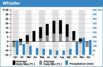
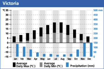
I will be contrasting my location of Vancouver Island/Victoria BC with Whistler BC. Link: http://whistlerbcweather.blogspot.com/
Since I have evaluated much of BC’s climate as a province in general, there are obviously many similarities between the two locations (Coast of Vancouver island and Whistler). There are in the same region, with the same air masses affecting them and same climate zones. They both experience warm summers with light rains and cold winter with more precipitation in the summer. There are in fact some minimal differences though, which I would like to focus on.
Whistler is about 125 KM north, inland from Vancouver Island, which very close to the location I created my climograph on. Whistler is more inland from my station, which is situated by the coast of an island. It is located among the Coast Mountains. Warm air masses in the winter come in from the coast of Vancouver island and go inland, and these mountains then lift and block these air masses, causing and abundant amount of snow to fall on the West side of the mountain. This is why Whistler is so well know for powder skiing and its abundant amounts of snowfall. Vancouver island therefore, doesn’t get this affect of precipitation, and receives less snowfall than Whistler does inland.
Whistler is also higher in elevation than Vancouver island is (7,156 miles vs. sea level) and therefore also experiences cooler temperatures than my station, especially in winter months.
In general these are very similar climates because they lie in the same province in BC Canada. Although seemingly one would think they would have identical climates, this isn’t true because British Columbia itself has many climate controls that affect it’s weather annually. This area of the world is dominated by mainly factors, mainly by the warm air from the Pacific Ocean, and by the changes of this air from the mountain ranges inland. The differences between an area such as Vancouver island and Whistler may seen minimal until examined more clearly and in depth.
http://www.hellobc.com/vancouver-coast-mountains/climate-weather.aspx
These two graphs can be used to compare and contrast visually the temperature and precipitation differences in these two areas within the same province of Canada.
Sources:
http://en.wikipedia.org/wiki/Geography_of_British_Columbia#Climate
http://www.hellobc.com/british-columbia/about-bc/climate-weather.aspx
http://en.wikipedia.org/wiki/Whistler,_British_Columbia
http://www.hellobc.com/vancouver-coast-mountains/climate-weather.aspx
http://en.wikipedia.org/wiki/Geography_of_British_Columbia#Climate
http://www.hellobc.com/british-columbia/about-bc/climate-weather.aspx
http://en.wikipedia.org/wiki/Whistler,_British_Columbia
http://www.hellobc.com/vancouver-coast-mountains/climate-weather.aspx
 RSS Feed